![Item #285041 [MAP] DANIAE CUM SERIE INSULARUM SUARUM REGN. (ATLAS PORTALIS). Johann Cristoph Weigel](https://blackswanbooks.cdn.bibliopolis.com/pictures/285041.jpg?width=320&height=427&fit=bounds&auto=webp&v=1538084369)
[MAP] DANIAE CUM SERIE INSULARUM SUARUM REGN. (ATLAS PORTALIS)
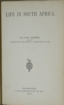
[Nürnberg]: [c. 1720]. A hand colored plate of Denmark, from either the First or Second Edition of Johann Cristoph Weigel’s Atlas Portalis. Beginning of separation along the crease. About 20 x 17 cm.
![Item #285027 [MAP] EUROPAE RECENS DESIGNATIO. (ATLAS PORTALIS). Johann Cristoph Weigel](https://blackswanbooks.cdn.bibliopolis.com/pictures/285027.jpg?width=320&height=427&fit=bounds&auto=webp&v=1538255370)
![Item #285039 [MAP] IMPERIUM MOSCOVIAE. (ATLAS PORTALIS). Johann Cristoph Weigel](https://blackswanbooks.cdn.bibliopolis.com/pictures/285039.jpg?width=320&height=427&fit=bounds&auto=webp&v=1538084366)
![Item #285050 [MAP] ITALIA CUM INSULIS DEPENDENTIHG. (ATLAS PORTALIS). Johann Cristoph Weigel](https://blackswanbooks.cdn.bibliopolis.com/pictures/285050.jpg?width=320&height=427&fit=bounds&auto=webp&v=1538084381)
![Item #285049 [MAP] NEAPOLITANI REGNI TABULA. (ATLAS PORTALIS). Johann Cristoph Weigel](https://blackswanbooks.cdn.bibliopolis.com/pictures/285049.jpg?width=320&height=427&fit=bounds&auto=webp&v=1538084380)
![Item #285048 [MAP] NOVISSIMA FOEDERATORUM HELVETIORUM TABULA. (ATLAS PORTALIS). Johann Cristoph...](https://blackswanbooks.cdn.bibliopolis.com/pictures/285048.jpg?width=320&height=427&fit=bounds&auto=webp&v=1538084378)
![Item #285054 [MAP] REGNI HIPSANIAE DELINEATIO. (ATLAS PORTALIS). Johann Cristoph Weigel](https://blackswanbooks.cdn.bibliopolis.com/pictures/285054.jpg?width=320&height=427&fit=bounds&auto=webp&v=1538084386)
![Item #285042 [MAP] REGNI PRUSSIA. (ATLAS PORTALIS). Johann Cristoph Weigel](https://blackswanbooks.cdn.bibliopolis.com/pictures/285042.jpg?width=320&height=427&fit=bounds&auto=webp&v=1538084370)
![Item #285053 [MAP] REGNUM GALLIAE MODERNA. (ATLAS PORTALIS). Johann Cristoph Weigel](https://blackswanbooks.cdn.bibliopolis.com/pictures/285053.jpg?width=320&height=427&fit=bounds&auto=webp&v=1538084385)
![Item #285038 [MAP] REGNUM HUNGARIAE. (ATLAS PORTALIS). Johann Cristoph Weigel](https://blackswanbooks.cdn.bibliopolis.com/pictures/285038.jpg?width=320&height=427&fit=bounds&auto=webp&v=1538084365)
![Item #285033 [MAP] SPHAERARUM ARTIFICIALIUM TYPICA REPRAESENTATIO. (ATLAS PORTALIS). Johann...](https://blackswanbooks.cdn.bibliopolis.com/pictures/285033.jpg?width=320&height=427&fit=bounds&auto=webp&v=1538255370)
![Item #285046 [MAP] TOTIUS FLUMINIS RHENI ACCURATA DELINEATIO. (ATLAS PORTALIS). Johann Cristoph...](https://blackswanbooks.cdn.bibliopolis.com/pictures/285046.jpg?width=320&height=427&fit=bounds&auto=webp&v=1538084376)
![Item #285051 [MAP] XVII PROVINIAE BELGII. (ATLAS PORTALIS). Johann Cristoph Weigel](https://blackswanbooks.cdn.bibliopolis.com/pictures/285051.jpg?width=320&height=427&fit=bounds&auto=webp&v=1538084382)

![Item #297201 [ATLAS] SPRUNER-MENKE HAND-ATLAS FUR DIE GESCHICHTE DES MITTELALTERS UND DER NEUREN...](https://blackswanbooks.cdn.bibliopolis.com/pictures/297201.jpg?width=320&height=427&fit=bounds&auto=webp&v=1700518872)
![Item #292352 [ATLASES AND MAPS] A COMPLETE GENEALOGICAL, HISTORICAL, CHRONOLOGICAL, AND...](https://blackswanbooks.cdn.bibliopolis.com/pictures/292352.jpg?width=320&height=427&fit=bounds&auto=webp&v=1604880897)